


History UjungKulon at Glance
Before Ujung Kulon officially became a National Park in 1992
On the south western tip of the island of Java, where the vast expanse of the Indian Ocean and the equatorial waters of the Sunda Straits merge, is one of Indonesia’s paramount national parks, Ujung Kulon. Rich in wildlife and forest, noted for its charm and diversity, it is the home of the highly endangered
Javan rhinoceros and bestowed with the status of World Heritage (Natural) Site.
Ujung Kulon, which means West Point, possesses an exceptional profile of Indonesia’s wilderness form forested mountain ranges to coral seas. What makes it even more remarkable is that the park remains a pristine haven of nature, on Java, one of the most densely populated islands on earth.
In earlier centuries when the population was small and the forests were large, the people of the land lived with a deep respect for the forest and its wildlife. Then began a two century long struggle between mankind and nature. The world first became aware of the natural treasures of Ujung Kulon in the 1820’s when botanists began venturing onto the Peninsula to collect exotic tropical specimens. This was a time of colonial expansion and exploration and by the middle of the century expedition form the Organization for Scientific Research in the Netherland Indies drew attention to its unusual richness and scientific importance. They wrote of the Peucang Island area in 1853:
-“beautiful and safe bays…fertile soil…a wealth of timber for ship and shore…. a splendid situation for commerce….the seed of a new Singapore”.
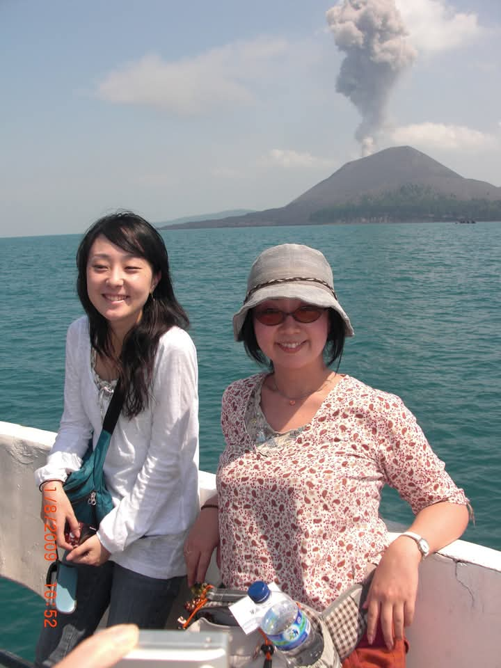
Despite their recommendations to exploit the park’s resources, and fortunately for future generations, nothing came of developing the region. Thirty years later in August 1883, nature intervened with a force that was un-known at that time when the nearby volcanic island of Krakatau erupted. It produced tidal waves that devastated the coastal areas destroying much of Ujung Kulon’s vegetation and northern coastlines. Some insight into the impact of the tidal waves was recorded by a British ship 222 km. south of Ujung Kulon on that day: “Encountered carcasses of animals including even those of tigers and about 150 human corpses borne along by the current.” 23 besides enormous trunks of trees However, the regrowth was rapid and created lush new vegetation on which the browsing wildlife thrived. The first steps toward the region becoming a national park began at the end of the 19th century when the Ujung Kulon peninsula was establishing a reputation as a big game hunting area. During the following decade there was no other region in all of Java with as much game and so the trophy shooters came and animals were killed without limitations. A group of conservationists and game hunter became concerned about the declining animal numbers and that some species were nearing extermination. This led in 1910 to the government’s first decree protecting some of the fauna, however the hunting continued.
Two years later came the formation of the Netherlands Indies Society for the Protection of Nature. Their efforts had very little effect until 1921 when the Society was granted 300 sq. kilometers of the Ujung Kulon Peninsula as a nature reserve. Panaitan Island was also protected as a separate reserve. There was however no supervision and during the 1930’s hunting arties shot numerous animals.
In 1937 the status of the reserves was change management of the Director of the Botanical Gardens in Bogor. Over the following few years the Ujung Kulon Game Reserve was closed to the public, a guard system was introduced and it appeared that Ujung Kulon and its wild – life had a promising future. Then came the Second World War followed by Indonesia’s struggle to establish independence. The situation in the Ujung Kulon Game Reserve deteriorated as management became difficult and many rhinos and other animals were once again being killed.
After the formation of the Republic of Indonesia, the Ujung Kulon Panaitan Island Game Reserve was again declared a Nature Reserve in 1958 and the coastal boundaries were extended 500 metres seaward. To the east of the Ujung Kulon Peninsula 20,000 hectares of the Gunung Honje Range also became nature reserves and guarding was re-introduced to the region.
Ujung Kulon officially became a national park in 1992. In the same year, along with the Krakatau Islands, the park shared the distinction of becoming Indonesia’s first World Heritage (Natural) Site along with the Komodo Islands. As with all national parks in Indonesia, Ujung Kulon is managed by the Republic of Indonesia’s Department of Forestry under the Directorate General of Forest Protection and Nature Conservation.
Navigating Indonesian Trips Companies: Your Guide to Authentic Journeys with PT UJUNGKULON TOURS
Choosing suitable Indonesian trips companies ensures an authentic and safe travel experience. Focus on local expertise, clear pricing, and reliable support. PT UJUNGKULON TOURS offers deep wilderness ecotours, while PT Java Bali Trips handles cultural overland journeys, providing tailored, specialized adventures across Indonesia. Both companies are the top ten reliable tour companies in Indonesia.
When planning a trip to Indonesia, finding the right provider among many Indonesian trips companies makes all the difference. You want an adventure that aligns with your interests, ensures your safety, and connects you with the local culture or environment authentically. It is about selecting a partner who understands the destination intimately.
📑 Contents
Finding the Right Fit Among Indonesian Trips Companies
Choosing among various Indonesian trips companies requires careful thought. What makes one company a better choice than another for your particular journey? Often, it comes down to specialized local knowledge and dedicated service.
Local Expertise and Focus
Many larger travel platforms offer generic packages. However, for a truly immersive experience, specialized local operators often deliver more. Unlike massive digital travel platforms, these sister agencies are highly specialized, boots-on-the-ground local operators. PT Java Bali Trips focuses on long-haul multi-day cultural overlands, temple exploration, and island transitions (Borobudur, Bromo, Ijen, Bali). PT Ujungkulon Tours and Travels operates deep in the wilderness, organizing raw ecotourism, jungle trekking, and boat expeditions to find the critically endangered Javan rhino. This distinction means you are with guides who know the terrain, the people, and the wildlife firsthand. Based on our field experience, this level of local integration often results in more genuine interactions and smoother logistics, especially when venturing off the main tourist routes.
Safety Protocols and Support Systems
Travel to new places always involves an element of the unknown. Reputable Indonesian trips companies prioritize your safety. They implement clear safety protocols, maintain well-serviced transportation, and employ trained guides. You should expect transparent communication about contingency plans. Good support extends to readily available assistance should any unexpected situation arise during your journey. Checking their track record for handling emergencies gives you confidence.
Reputation and Honest Feedback
Before committing, look into what past travelers say about specific Indonesian trips companies. Reviews on independent platforms or direct testimonials offer insight into service quality, guide professionalism, and overall trip satisfaction. A pattern of positive feedback, especially concerning responsiveness and adherence to itineraries, indicates a reliable provider. We often find cases where a company’s reputation for clear communication becomes a major deciding factor for travelers.
Understanding Trip Types and Estimated Market Prices
Indonesia offers an immense variety of travel experiences, from cultural immersion to rugged adventure. The costs associated with these trips vary widely depending on duration, inclusions, and type of experience. It’s helpful to understand what different Indonesian trips companies offer and the general market ranges.
Cultural and Overland Journeys
These tours typically explore historical sites, local villages, and significant cultural landmarks. Think of multi-day trips across Java, visiting ancient temples and volcanoes. These often involve a mix of private transport and guided excursions.
For such cultural and overland journeys, the estimated market prices can range from IDR 3,000,000 to IDR 10,000,000 per person for a 3-5 day tour, depending on accommodation quality, group size, and specific inclusions. For a deeper dive into Bali and Java’s cultural routes, PT Java Bali Trips offers tailored experiences; you can learn more about these diverse programs at Java Bali Trip.
Adventure and Ecotourism Expeditions
For those seeking closer encounters with nature, adventure and ecotourism trips are popular. This includes jungle trekking, wildlife spotting, and exploring remote natural areas. Companies like PT UJUNGKULON TOURS specialize in these raw experiences, taking you into places like Ujung Kulon National Park to witness its unique biodiversity, including the critically endangered Javan rhino. Understanding ecotourism principles, which focus on responsible travel to natural areas that conserves the environment and improves the well-being of local people, is key to appreciating such trips. You can read more about ecotourism on Wikipedia.
These ranges are general market estimates and can fluctuate based on the specific itinerary, level of luxury, number of travelers, and time of year. Always request a detailed quote from Indonesian trips companies for precise pricing.
Practical Tips for Choosing the Best Indonesian Trips Companies
Making the right selection requires a bit of homework. Here are some actionable steps to help you decide.
Ask Specific Questions
Don’t hesitate to ask detailed questions about the itinerary, accommodation, transportation, and what is included in the price. Clarify guide qualifications, group size, and any physical requirements for activities. A reputable company, especially among top Indonesian trips companies, will gladly provide comprehensive answers. This helps avoid surprises and ensures the trip matches your expectations.
Confirm Inclusions and Exclusions Clearly
Always get a clear breakdown of what your payment covers. Are meals included? What about national park fees, permits, or local transportation? Understanding what’s excluded helps you budget for additional expenses. Practical tips from our team: always check for hidden costs like additional activity fees or mandatory local guide tips that might not be explicitly stated upfront. Transparency here is a strong indicator of a trustworthy provider among Indonesian trips companies.
Look for Flexibility and Customization Options
Some travelers prefer a fixed itinerary, while others value the ability to customize. If you have specific interests or require particular arrangements, inquire about the company’s flexibility. Specialized Indonesian trips companies, like PT UJUNGKULON TOURS, often excel at creating tailored experiences. This level of service shows they genuinely want to create a journey just for you, rather than fitting you into a standard package.
Choosing the appropriate Indonesian trips companies transforms a simple journey into a memorable expedition. By focusing on local expertise, transparent pricing, and robust support, you can find a partner that delivers an experience beyond just travel. Whether you seek cultural insights with PT Java Bali Trips or a deep dive into Indonesia’s wild heart with PT UJUNGKULON TOURS, the right provider makes all the difference.
Ready for an Unforgettable Indonesian Adventure?
Don’t settle for generic trips. Contact PT UJUNGKULON TOURS today to design your specialized ecotourism journey or cultural exploration.
Plan My Indonesian Trip
FAQ
How do I choose between different Indonesian trips companies?
Focus on companies with local expertise, clear safety records, positive reviews, and transparent pricing. Consider what type of experience you want (cultural, adventure, ecotourism).
What types of trips do Indonesian companies typically offer?
Offerings vary widely, including cultural tours, adventure treks, ecotourism expeditions, island hopping, diving trips, and customized private journeys.
Are specialized Indonesian trips companies better than large international ones?
Often, specialized local companies provide more authentic experiences, deeper local insights, and more flexible itineraries, especially for specific regions or niche interests.
What should I expect regarding pricing for trips in Indonesia?
Prices vary significantly based on trip duration, inclusions (accommodation, meals, transport, guides, permits), group size, and luxury level. Always ask for a detailed breakdown.
How can I ensure the company is responsible and sustainable?
Look for companies that emphasize ethical practices, support local communities, and follow environmental conservation guidelines. Many specialized ecotourism operators highlight these commitments.
Is it possible to customize an itinerary with Indonesian trips companies?
Yes, many local operators, particularly those focusing on niche experiences, are willing to customize itineraries to match your specific interests and schedule.
What payment methods do Indonesian trips companies usually accept?
Most reputable companies accept bank transfers, credit card payments, or international payment gateways. Always confirm preferred payment methods and any associated fees.
Best Reviews Movenpick Resort Carita Experience
This article offers an in-depth look at the Movenpick Resort Carita, drawing from personal experience and guest feedback. It covers accommodation, dining, amenities, and service, providing a truthful perspective on what to expect. This guide helps you decide if this resort aligns with your travel plans, offering a transparent view of its offerings.
Choosing a retreat spot means weighing various factors. When considering the Movenpick Resort Carita, you want clear insights into what awaits. This guide gathers the best reviews Movenpick resort Carita has received, offering a firsthand account and practical information to help your planning. Our goal is to present a straightforward picture, helping you determine if this destination meets your expectations.
📑 Contents Movenpick Resort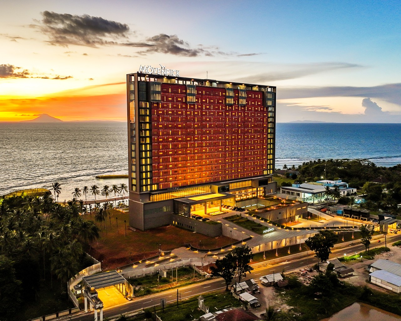
Experiencing the Movenpick Resort Carita: First Impressions and Stay Comfort
Our arrival at the Movenpick Resort Carita revealed its distinct character immediately. Unlike many older, sprawling resorts along the Anyer coast, Mövenpick stands out with its modern 20-story tower architecture. This design choice is not just for appearance; it allows nearly every guest a direct, unobstructed view of the Sunda Strait sunset. This is a point many of the best reviews Movenpick resort Carita highlight, and it’s certainly a notable difference from other places.
Stepping out onto the balcony of our Deluxe Terrace room, the first thing that catches you is the open view of the Sunda Strait. Unlike the older, spread-out resorts in Anyer, Mövenpick’s 20-story modern tower architecture gives every single guest a direct sunset vantage point. We spent our afternoon tracking lengths across the massive 70-meter beachfront infinity pool before heading up to the open lobby just in time for the complimentary daily Chocolate Hour. While the beach itself has coral patches in some areas, the sheer volume of amenities—including a top-tier indoor golf simulator and an outdoor ATV path—keeps you completely entertained without needing to step foot off the property. This firsthand experience shapes our perspective on the best reviews Movenpick resort Carita.
Guestrooms reflect a contemporary style, equipped with amenities expected of a modern resort. You will find comfortable bedding, efficient air conditioning, and clean, well-maintained bathrooms. Views vary, but many rooms do offer that ocean glimpse that makes a beach vacation special. Our team has observed that consistent room upkeep directly impacts guest satisfaction, and Movenpick generally maintains high standards in this area. These aspects contribute significantly to positive feedback found in the best reviews Movenpick resort Carita.
Dining and Culinary Offerings
The resort provides several dining options. From breakfast buffets to a la carte menus, the food quality and variety are generally well-received. You can expect a mix of local Indonesian dishes and international cuisine. For those who enjoy something sweet, the daily Chocolate Hour is a signature Movenpick offering, often mentioned positively in best reviews Movenpick resort Carita. It adds a pleasant, indulgent touch to the afternoon. Based on our field experience, consistent food quality and friendly service make a real difference, and the Movenpick kitchens strive for this.
Amenities and Recreational Pursuits at Movenpick Carita
Beyond comfortable rooms and good food, the activities and facilities available often determine how much guests enjoy their stay. The Movenpick Resort Carita offers a range of options, catering to different interests. The standout feature is its large beachfront infinity pool. You can spend hours by the water, whether swimming laps or simply relaxing with the sound of the waves. Many best reviews Movenpick resort Carita commend the pool area for its size and views.
For those seeking more active pursuits, the resort has an indoor golf simulator. This is a neat addition, particularly if you are a golf enthusiast looking to practice your swing regardless of the weather. Additionally, an outdoor ATV path provides a chance for adventure and off-road exploration within the property grounds. Families will appreciate the dedicated children’s facilities, which aim to keep younger guests occupied and happy.
The beach itself, while beautiful, does have coral patches in some areas. This is something to be aware of, especially if you plan to swim directly from the shore. However, the range of on-site activities means you have plenty to do without venturing far. We often find cases where resorts with extensive internal offerings truly elevate the guest experience, making external excursions less necessary for entertainment. This contributes to many positive elements found in the best reviews Movenpick resort Carita.
Exploring the Local Area: Carita Beach and Beyond
While the resort offers ample entertainment, you might want to explore the surrounding Carita area. Carita Beach itself is a popular destination on the west coast of Java, known for its scenic beauty and calm waters. It’s a place where you can find local vendors, enjoy fresh seafood, and experience a different pace of life. For more information on the geography and appeal of the region, you can consult resources like the Wikipedia page for Carita, Indonesia.
Local activities often include snorkeling, banana boat rides, and trips to nearby islands or volcanic areas. While the Movenpick provides a serene setting, connecting with the local environment can add another dimension to your trip. When you consider the best reviews Movenpick resort Carita, remember that the surrounding area complements the resort experience. Practical tips from our team suggest always checking local conditions and availability for external activities before your trip.
Understanding Estimated Stay Costs for Movenpick Carita
Budgeting for a vacation often begins with understanding potential costs. While specific rates for the Movenpick Resort Carita vary by season, room type, and booking platform, we can offer a general guide based on similar luxury properties in the region. Estimated stay costs at luxury resorts in the Carita area, including those offering facilities comparable to Mövenpick, generally range from IDR 1,500,000 to IDR 4,000,000 per night. This range typically covers standard rooms to deluxe suites and might include breakfast, depending on the package.
This figure gives you a benchmark for planning your trip. Factors that influence these prices include public holidays, school vacation periods, and weekend stays, which often see higher rates. Booking well in advance or looking for package deals can sometimes help manage these costs. When reading best reviews Movenpick resort Carita, remember that the value often comes from the comprehensive amenities and service provided. Always check current promotions directly with the resort or trusted travel partners for the most precise pricing. For PT UJUNGKULON TOURS, we emphasize getting a clear cost picture to avoid any surprises.
Final Thoughts on the Best Reviews Movenpick Resort Carita
After considering the various aspects—from its distinct architecture and room comforts to its extensive amenities and dining choices—the Movenpick Resort Carita presents a appealing option for a coastal retreat. The unique tower design ensures memorable sunset views for many guests, a feature consistently praised in the best reviews Movenpick resort Carita. While the beach has its specific characteristics with coral patches, the wide array of activities within the resort property means you have many choices for relaxation and entertainment. From the expansive infinity pool to unique offerings like the golf simulator and ATV path, the resort aims to provide a full experience.
This candid look at the best reviews Movenpick resort Carita aims to give you a truthful account, moving beyond simple descriptions to offer a clearer expectation. For travelers seeking a modern resort with a strong emphasis on on-site facilities and a comfortable stay, it stands as a worthy choice.
FAQ
Does the Movenpick Resort Carita have beach access?
Yes, the resort has direct beach access. Guests should note that some parts of the beach have coral patches.
What unique amenities does Movenpick Resort Carita offer?
The resort offers a 70-meter beachfront infinity pool, an indoor golf simulator, and an outdoor ATV path, alongside standard facilities.
Are there dining options at the resort?
Yes, Movenpick Resort Carita features several dining venues offering a mix of local and international cuisine, including a daily complimentary Chocolate Hour.
What type of views can guests expect from their rooms?
Due to its 20-story tower architecture, many rooms offer direct views of the Sunda Strait, providing a clear sunset vantage point.
What are the estimated costs for a stay at Movenpick Resort Carita?
Estimated stay costs for luxury resorts in the Carita area, including those with similar facilities to Movenpick, generally range from IDR 1,500,000 to IDR 4,000,000 per night, depending on various factors.
Is the Movenpick Resort Carita suitable for families?
Yes, the resort provides dedicated children’s facilities and a wide range of activities that cater to families.
How does Movenpick Carita compare to older resorts in the area?
Its modern 20-story tower architecture gives it a distinct appearance and ensures many rooms have direct sunset views, differing from older, more spread-out resorts.
Need Help for Best Reviews Movenpick resort carita?
The PT UJUNGKULON TOURS team is ready to assist you — consult your queries now.
24/07 CS Service
Jakarta Tour Adventure: Discovering Unforgettable Experiences
Plan to try an adventure tour around Jakarta? This article explores a variety of activities, exciting locations, and estimated costs. Find a complete guide to thrilling experiences from trekking and river tubing to island hopping, along with practical tips from PT UJUNGKULON TOURS experts.
Seeking new sensations through an adventure tour around Jakarta is the perfect way to escape the city’s routine. Jakarta, with all its hustle and bustle, offers many gateways to unexpected adventures. From cool pine forests and fast-flowing rivers to small islands with their underwater beauty, you can reach them all in no time.
📑 Important Contents
Interesting Adventure Tour Destination Options Around Jakarta
When discussing adventure tours around Jakarta, many people might imagine long journeys. However, you can visit several interesting locations without the need for long travel times. These destinations offer a variety of activities that will get your adrenaline pumping and refresh your mind.
Trekking and Hiking in Bogor & Sentul
Bogor and Sentul are two popular areas for trekking and hiking. With its hilly terrain and pristine forests, these areas offer a wealth of adventure trails. You can discover hidden waterfalls, trek through rice paddies, or climb to the top of a hill for a bird’s-eye view of the city. Trails range from beginner to physically demanding.
Based on our team’s experience in the field, many adventure tour participants around Jakarta, particularly in the Bogor and Sentul areas, seek out routes that combine natural scenery and moderate physical challenges. This provides a unique sense of satisfaction upon completing the journey.
River Tubing and Rafting in Sukabumi & Cisadane
If you enjoy water activities, river tubing or rafting can be exciting adventure tour options around Jakarta. The thrill of navigating the river currents in a rubber boat or inflatable tube offers a unique experience.
We often find that safety is a top priority for participants. Make sure you choose an operator with complete equipment, experienced guides, and adherence to safety standards.
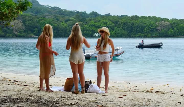
Exploring the Unique Marine Beauty of the Seribu Islands
The Thousand Islands are a hidden gem not too far from Jakarta. This destination offers captivating marine adventures far from the hustle and bustle of the city.
Snorkeling and Diving
For underwater enthusiasts, the Thousand Islands are a paradise. Islands like Pramuka Island, Harapan Island, and Pari Island offer captivating snorkeling and diving spots. You can swim with colorful fish and admire healthy coral reefs. This is another form of adventure tour around Jakarta that’s both relaxing and captivating.
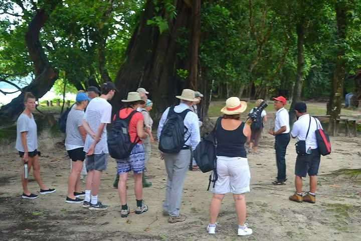
Practical tips from PT UJUNGKULON TOURS: To preserve the marine ecosystem, avoid touching or taking coral reefs. This underwater beauty is an asset we must all preserve. For those who want to see the beauty of preserved wildlife, especially the natural habitat of the Javan rhinoceros, consider exploring the wildlife in Ujung Kulon National Park. It’s a very different, yet equally thrilling, experience.
Island Hopping and Water Games
Besides snorkeling and diving, the Thousand Islands are also ideal for island hopping. You can visit several islands in one day, enjoying the different coastal views on each one. Some islands also offer water sports like banana boating or jet skiing. An adventure tour around Jakarta in the Thousand Islands will give you a new perspective on Indonesia’s natural riches.(read more: Practical Tips Exploring Ujung Kulon: A Journey into Indonesia’s Wilderness)
Important Aspects in Choosing an Adventure Package
Choosing an adventure tour package around Jakarta requires careful consideration. Several factors should be considered to ensure a safe and optimal experience.
Planning and Equipment
Each type of adventure requires different preparation. For trekking, make sure you wear comfortable shoes and bring a change of clothes. For water activities, bring swimwear and sunscreen. Always carry a refillable water bottle to reduce plastic waste.
Estimated Cost Adventure Tour Around Jakarta
The cost of an adventure tour around Jakarta varies greatly depending on the duration, type of activity, amenities, and number of participants. Estimated market prices for day trips (such as trekking or rafting) typically range from Rp 350,000 to Rp 1,500,000 per person. Island hopping packages to the Seribu Islands with overnight accommodation can range from Rp 800,000 to Rp 2,500,000 per person. These prices are subject to change depending on the provider and additional services.
Choosing a Trusted Operator
Choose a tour operator with a strong track record, especially regarding safety and guide experience. Ensure they have a valid business license and positive customer reviews. This is crucial to ensuring the smooth running of your adventure tour around Jakarta. For more information on safety tips for nature adventures, you can refer to Wikipedia’s ecotourism guide, which discusses the importance of responsible travel practices.
Choosing the right adventure tour around Jakarta can be a rewarding experience. With proper planning and careful operator selection, you’ll have an unforgettable experience. PT UJUNGKULON TOURS is committed to providing a safe and memorable adventure, close to nature, and tailored to your expectations. Enjoy every moment of your exploration!
FAQ
What are the most popular types of adventure tours around Jakarta?
Popular activities include trekking in Sentul/Bogor, rafting or river tubing in Cisadane/Sukabumi, and snorkeling and island hopping in the Seribu Islands.
What is the estimated cost for an adventure tour around Jakarta?
Estimated costs on the market range from Rp 350,000 to Rp 1,500,000 per person for a day package, and Rp 800,000 to Rp 2,500,000 per person for an overnight package, depending on the type of activity and facilities.
Are there any adventure tour options around Jakarta that are suitable for beginners?
Yes, there are many options suitable for beginners, such as a leisurely trek on Mount Pancar or rafting on the Cisadane River with its gentle currents.
How to choose a trusted tour operator?
Choose an operator with a good track record, positive reviews, experienced guides, and make sure they adhere to safety standards.
What do I need to prepare to join an adventure tour around Jakarta?
Bring comfortable clothing and shoes, gear appropriate for the activity (e.g., swimwear for water activities), a refillable water bottle, and sun protection.
Can I go on an adventure tour around Jakarta alone or do I need a guide?
For safety and a better experience, especially in unfamiliar areas, it’s highly recommended to go with an experienced guide or tour operator.
Need help with an adventure tour around Jakarta?
The PT UJUNGKULON TOURS team is ready to assist you — consult your needs now.
Contact us now!